
Global geospatial mapping specialist GeoSLAM has expanded its mining offering, building on its reputation in the sector to provide advanced underground mining solutions. The news follows the unveiling of its automated processing platform, GeoSLAM Connect, which provides users with the flexibility to process their data to their exact specifications through a series of interactive customizable script-based workflows. Many features of Connect are particularly useful for the mining sector, including the automatic georeferencing.
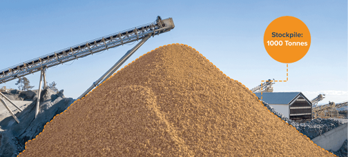
Underpinned by the software and backed by the company’s expertise in the mining sector, the new innovations include production progress mapping, convergence analysis and vertical mine shaft inspection monitoring – all of which will sit alongside the existing solutions already available and in-use across the globe, including GeoSLAM Volumes for stockpile volumetric calculations.
Commenting on the launch of the new mining solutions, CEO and founder of GeoSLAM, Graham Hunter, said, “We’ve worked in the mining sector for a number of years, alongside the industry’s major worldwide players to understand their needs and challenges so I’m delighted to announce our latest offering, supported by our state-of-the-art Connect software, that will continue to bolster our mining offering.
“Our aim is to help mine owners and workers overcome the number of hurdles they face in their day-to-day occupations; improving accessibility to ensure worker safety, speeding up operations and giving mining teams foresight into the changing underground environment by delivering precise and real-time data, as well as keeping costs to a minimum while producing maximum output and driving revenue.
“These innovations are designed to be operated using our existing ZEB family of scanners and, best of all, the ease of use means they can be used without any prior training. In just a matter of minutes, with no interruption to the mining teams, mine owners can have reliable and accurate data at their fingertips, saving both time and money in what is an already demanding sector.”
Building on its reputation within mining, the first of its new applications is GeoSLAM Production Progress Mapping – which, when coupled with a ZEB scanner and its own internal co-ordinate system, allows operators the flexibility to make short-term operational decisions on newly-mined production areas in quick time in a “mining-to-plan” process.
Once the data from each scan has been automatically processed and georeferenced using GeoSLAM Connect, it can be uploaded to any compatible third-party software. Operators will be able to overlap collected data and precisely visualize changes of an area over time to compare with project plans – giving mine owners the freedom to analyze, make real-time decisions and avoid production hold-ups.
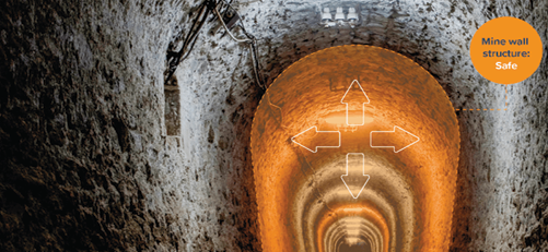
Mining has long been viewed as a hazardous occupation, but digital technologies like GeoSLAM’s new Convergence Analysis however, are reshaping this outlook by providing mine owners with a rapid and cost-effective way to understand the environment while keeping miners safe.
Utilizing GeoSLAM’s unique SLAM (simultaneous localization and mapping) algorithm to create clear 3D visualizations, mine operators will be able to quickly measure rock support – including detecting failure points, the velocity of change, potential slope and areas of displacement – all while remaining at a safe distance, and without the need to disrupt crews, due to the speed of capture.
Completing the trio is GeoSLAM’s purpose-built shaft inspection cradle, built for collecting data during inspections and analyzing change. From above ground, it allows users to understand the erosion of a shaft wall, view blockages and identify hanging points for ore in hard-to-reach and dangerous vertical shafts.
Issued as standard with each ZEB sale, its support package, GeoSLAM Care, offers mining customers unlimited access to hardware and remote software support, the latest software releases and access to GeoSLAM Academy; a portal of resources for customers to use including user training, videos and best practice information.
For more information on its existing and expanded mining offering, visit the website or click here to understand how handheld SLAM scanners are revolutionizing the underground mining industry.
GeoSLAM, geoslam.com/industries/mining