
Mine Planning and Inventory Management at Edw. C. Levy Co.
By Mark S. Kuhar
In 1918, Edward Levy Sr. shook the hand of Henry Ford, and the Edw. C. Levy Co. was born. Since those early years, the Levy Group of Companies in Michigan has grown and flourished, becoming a premier, national construction-materials company.
The company’s business lines are vast, everything from steel-mill services and slag processing; to aggregates and concrete production; to road construction.
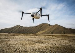
In 2016, the company began to see the benefits of using Kespry drones for quicker, better and faster topographic surveys, according to Matt Van Slembrouck, mine engineer. But it wasn’t long until the company discovered additional benefits, such as inventory management.
“Before we stated with Kespry it was an inexact science really,” Van Slembrouck said. “We used a combination of tribal knowledge and best guess to manage inventory.”
The company then moved into ground-based surveying, which was labor intensive and again, inexact. “Our data was based on what we could collect, which involved walking stockpiles,” he said. “We also did aerial flyovers and we were spending a lot on that. We needed a way to get the information faster and more accurately.”
Embracing Kespry
Kespry did a demo in Detroit for the company. It opened a few eyes. “We saw data the next day and we were impressed,” Van Slembrouck said.
Kespry explained that customers use its technology to autonomously measure stockpile volumes and manage inventory across their sites because it produces data that is up to 80% more accurate than manual measurement or using other drone solutions. All their survey data is stored in one central cloud application. The data is accessible by the entire team for analysis and can also easily be used in their operational systems.
It was enough to convince Edw. C. Levy Co. that it needed its own drone.
Fortunately, adding a drone didn’t mean adding new employees. A group of Edw. C. Levy employees were cross-trained and earned their Part 107 license.
“We use the drone a lot,” Van Slembrouck said. “The primary use is measuring stockpiles, but we also use it to inspect highwall faces. We use it for our annual mine planning: it is a great tool to adjust calculations on current conditions.”
These highly-accurate data sets are captured in as little as 30 minutes without the need to use multiple, cumbersome ground control points or to have a surveyor walk the site, Kespry noted.
Other uses are tailings pond inspections. Low-level flight can be very useful for gathering information on the ponds, looking for erosion, trees popping up and gathering intelligence to prevent possible future incidents. The drone is also used to collect map information for the country.
“The learning curve is very quick,” Van Slembrouck said. “Their system works seamlessly with AutoCad and other downloadable formats, and is very cost-effective.”
Kespry touts its three-step process. There are no joysticks to worry about. There are no SD Cards to fumble with. There are no complicated data conversion applications for processing. It’s one complete solution from drone to data.

Step One: iPad Mission Planning and Autonomous Flight
An iPad app walks you through a simple three-step process:
1. Determine the area to survey or inspect.
2. Identify flight heights to capture data.
3. Complete preflight checklist to ensure the mission is safe and compliant.
Once the drone is launched by tapping the “take-off” button, the drone flies the mission plan autonomously, then returns to the take-off area for landing.
Step Two: Automated Analysis
This consists of in-the-field roof assessments and rapid delivery of survey data for mining and construction. Once the drone data has been captured, it is uploaded to the Kespry Cloud.
With the Kespry inspection solution, fast processing and mobile tools enable access to drone data within minutes, providing “in the field” analysis and claims decisions in as little as one hour.
For aggregates, mining, and construction, Kespry automatically generates 2D and 3D models of the entire site ready for analysis.
Step Three: Business Insights, Analytics and Reports
A complete model of a site or roof is available for users to accurately determine distances, elevations and volumes.
For insurance applications, high-resolution roof reports using industry standard processes such as test squares and dimensional analysis can be used to resolve claims decisions or be shared with claims processing systems.
Aggregates, mining and construction users can generate stockpile volumes, cut/fill analysis, and detailed topography across an entire site. This analysis can then be outputted to the system or process used to plan and manage that site.
“Kespry also gives us great back-end support,” Van Slembrouck said. “The company has certainly been great to work with.”
