
Accurate Measurement Of Inventory Can Save Aggregates Producers Time And Money.
Aggregates producers are quickly finding out that automated drone systems can improve how a company measures aggregate stockpiles, and save them a lot of money.
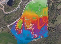
Like many aggregate companies, Whitaker Contracting and Madison Materials have measured stockpiles for decades using a combination of employees on the ground and third-party surveyors, per the following:
- Employee – Each of the three sites has 30 large stockpiles, and it took a full week to collect and analyze each site. Surveys happened four times per year and resulted in 576 annual man hours, at $30 per hour and $17,280 annual employee time cost.
- Equipment – Finance team estimated that the survey and GPS equipment costs the company $11 per hour, which is another $4,752 annual equipment cost.
- Third Party – Whitaker also hired third-party surveyors to assist with stockpile measurements, mostly with end-of-year inventory, and did one survey by ground at a cost of $4,800, and one by air at a cost of $11,000, or a $15,800 total annual cost for third-party measurement. Combined, the previous annual cost of measuring the Whitaker stockpiles was $37,832 with a six-times-per-year frequency.

New Method
With the Kespry Automated Drone System, Whitaker pays for the system up-front and then can measure as many sites and stockpiles as they want on their own. The new process is faster and cheaper, according to the company.
- Employee – The same employee flies the Kespry automated drone over each site, taking just a few hours per site. For this reason, Whitaker has increased their stockpile measuring frequency to 12 times per year, resulting in 144 annual man hours at $30 per hour and $4,320 annual employee time cost.
- Equipment – The annual cost of the Kespry Drone System was $25,000 for all the integrated hardware and software components, including unlimited flights, data analysis, data storage communications, online storage, maintenance and support.
- Third Party – After using Kespry’s Drone System, Whitaker no longer has the need to hire third-party surveyors.

Clear ROI
Combined, the new annual cost to Whitaker is $29,320, which is 22 percent less than before, and Whitaker is now able to measure their stockpiles twice as frequently, while spending four times less time overall. The Kespry Automated Drone System has clearly paid for itself on just stockpile measurement efficiency and savings, the company said.
New Drone Design
Based on requests from commercial customers, the new Kespry Drone 2.0 now flies more than 30 minutes per flight, covering up to 150 acres at a 400-ft. altitude, and can operate effectively in up to 25-mph sustained winds and 35-mph wind gusts. “With the lighter and faster Kespry Drone 2.0, Lehigh Hanson sites will be able to map larger areas faster,” said Mike Moy at Lehigh Hanson. “The expanded ground coverage and obstacle avoidance will allow the plants to more effectively manage their inventories, safely assess mine pits, and help control costs.” The Kespry Drone 2.0 weighs under 2 kg, which puts it in the “Micro UAV” category for streamlined regulatory compliance around the world. Kespry delivers a fully-automated drone system, which takes off, flies the designated flight path and lands, all without operator intervention or even a joystick. To help customers operating in congested areas, the new Kespry Drone 2.0 is the first automated drone system that includes an on-board LiDAR sensor that automatically detects and avoids obstacles like trees, cranes and buildings. The Kespry Drone 2.0 also has a lighter-weight and customized Sony industrial camera that captures more geospatial data for detailed 3D models that assist companies in areas like mine planning, operations, inspection and safety. “We’ve seen increased demand from technology partners like Kespry in the drone and robotics markets,” commented John Monti, director of visual imaging solutions at Sony Electronics. “The new lightweight Sony UMC-R10C is designed specifically for industrial applications leveraging low weight while maintaining high-quality image capture.” The Kespry Drone 2.0 continues to be the only fully automated and integrated commercial drone system that’s easy for companies to deploy at scale, the company said. The Kespry Drone, Kespry App and Kespry Cloud reporting systems all work together seamlessly, so companies can quickly collect and analyze valuable aerial intelligence. |
 Kespry, which designs automated drone systems for commercial use, announced the new Kespry Drone 2.0. The new lighter-weight drone flies twice as long, covers twice the ground area, and has twice the wind resilience, due to the new airframe, battery and flight-system improvements.
Other Benefits
The leader at Whitaker on this drone project has been John Davenport, who in a short amount of time has become an industry expert on drones, advising not only peer companies about his experiences, but sharing valuable information back to Kespry to improve their product.
Along the way, Davenport has uncovered some other real and exciting benefits from drones, well beyond the initial cost savings.
- Safety and Inspection – Aggregate stockpiles and cliff faces are dangerous to climb and inspect, so Whitaker is much happier to have Davenport safe on the ground while the drone flies overhead. It’s safer, faster and easier for everyone – especially in Alabama’s heat and rain.
- New Opportunities – Davenport is flying the Kespry drone more than 24 times per year, with only half of those flights being for stockpile measurement. The team at Whitaker is also using the Kespry Drone System for quarry inspection, mine planning and mine operations. Additionally, they’re finding the Kespry drone to be a great tool for construction and road projects, to verify aggregate and excavation amounts. Whitaker also includes the Kespry aerial images and 3D models in their customer proposals and project updates.

In summary, Whitaker is extremely satisfied with the Kespry drone costs savings for stockpile measurement, but the company is even more excited about the new opportunities that Kespry drones are helping create for their business.
Other Producers Weigh In
“With the drone we can get a cost efficient and accurate measurement of our stockpiles every month, versus the quarterly measurements we were getting before,” said Mike Moy of Lehigh Hanson. In addition to measuring stockpiles, Moy next plans to use the Kespry drone system for mine planning and reclamation projects.
“The Kespry Cloud, fueled by efficient, repeatable Kespry UAV flights, allows us to quickly collect site information, process it, and deliver results to our customers,” said Mark Power, survey team leader at infrastructure-management firm Woolpert.
“We use the Kespry Drone System to measure stockpiles, manage inventory and for pit planning, as well as surveying new and existing quarry locations for construction projects across Alberta Canada,” said Chris Hendsbee, crushing operations manager for Wapiti Gravel Suppliers.
Accurate measurement of inventory ensures that you never have to write down thousands of dollars in losses, or reconcile end-of-quarter discrepancies, according to the experts at Krespy. And that is something worth thinking about.
This article is adapted from a presentation made in March 2016 at AGG1 in Nashville by David Reed of Whitaker Contracting and Adam Rice of Kespry.