
Canada is a major consumer of premium frac sand from the Midwest of the United States, although they have sources that are currently mined in Alberta and Saskatchewan, with others in Manitoba scheduled to come online in 2015.
To improve their independence from the U.S. market, Canadian companies and provincial agencies have undertaken an extensive effort to identify and develop their own frac sand sources. Production and reserve values are shown in units as published in the cited references. No standard use of either metric or English units is implied in cases where the unit is reported only as “ton” by the original source.
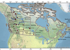
Alberta
Peace River: The Peace River Frac Sand Quarry, which is owned and operated by Canadian Silica Industries, produces frac sand from the Lower Cretaceous Paddy Member of the Peace River Formation. The Peace River Frac Sand Quarry reportedly has a total annual capacity of 500,000 tonnes of silica sand. This operation is located in close proximity to the Horn River and northwestern Deep Basins, and is central to the frac sand market within northwestern Alberta (The Wall Street Journal, 2014).
Fort McMurray: A frac sand deposit known as the Firebag deposit is north of Fort McMurray. Athabasca Minerals has a prospective frac sandstone deposit in this area with an estimated capacity of 1,000,000 tpy (Claim Post Resources Inc., 2013). Preliminary testing indicates that the Firebag sand meets or exceeds API/ISO specs for frac sand. A location that is 1,200 mi (about 2,000 km) closer to key Canadian markets makes this project advantageous.
British Columbia
The Rocky Mountain foothills between Mackenzie and Fort St. John: The Middle to Upper Triassic Liard Formation, the Upper Triassic Charlie Lake Formation; and the Upper Jurassic to Lower Cretaceous Monteith Formation and Lower Cretaceous Monach Formation of the Minnes Group are the most prospective bedrock units assessed for potential frac sands in the province (Hickin and others, 2010).
The Liard Formation is mainly a calcite-cemented, fine- to medium-grained, well- to sub-rounded to sub-angular, 90 percent quartz arenite of marine shoreface origin (Hickin and others, 2010). The Charlie Lake Formation is a calcite-cemented, fine- to medium-grained, well- to sub-rounded, feldspathic arenite of marine intertidal origin (Hickin and others, 2010). The Monteith Formation is a silica-cemented, fine- to medium- to coarse-grained, sub-angular to sub-rounded, 95 percent quartz arenite of deltaic origin (Hickin and others, 2010). The Monach Formation is a medium- to coarse-grained sand and coarse to granule conglomerate, rounded to sub-rounded, 95 percent quartz arenite of deltaic origin (Hickin and others, 2010).
Horn River Basin: unconsolidated deposits with good potential as frac sands include the Komie glaciofluvial delta deposits on the western edge of the Horn River Basin (Hickin and others, 2010).
Dawson Creek: unconsolidated deposits with good potential as frac sands include the Redwillow glaciofluvial delta south of Dawson Creek (Hickin and others, 2010).
Fort Nelson: unconsolidated deposits with good potential as frac sands include the aeolian deposits of the Fontas Dune Field southeast of Fort Nelson (Hickin and others, 2010).
Golden: The Moberly frac sand project is due to expand its glass sand mine for potential frac sand with an estimated capacity of 300,000 tpy (Claim Post Resources Inc., 2013).
Prince George, Nelson: Stikine Energy Corp. has two active frac sand exploration projects, the Nonda and Angus projects, each having an estimated capacity of 1,000,000 tpy (Claim Post Resources Inc., 2013). These are north of Prince George near the Yukon border (Levson and others, 2012). The projects will require processing that includes crushing, liberation and cleaning/sorting (Stikine Gold, 2014). The Nonda project is 93 mi (150 km) west of the Horn River Shale Basin, consists of a quartz-pure sandstone in 40/70 and 100 mesh sizes that is very homogeneous and has a surface exposure >7.1 mi x 0.6 mi (>11.5 km x 1 km) (Stikine Gold, 2014). The Angus project is 124 mi (200 km) south of the Montney Shale Basin, consists of quartz-pure sandstone in 20/40, 30/50 and 40/70 mesh sizes that has a surface exposure of >3.1 mi x 0.6 mi (>5 km x 1 km) (Stikine Gold, 2014).
West of Flin Flon: Hanson Lake Sands has a frac sand deposit with an estimated capacity of 800,000 tpy (Claim Post Resources Inc., 2013).
Northwest Territories
Fort Liard: Silica North Resources, Ltd., has an active frac sand exploration project (Levson and others, 2012).
Mackenzie River: less than optimally accessible quartz-rich sandstone of the Proterozoic Katherine Group and the Cambrian Mount Clark Formation occurs along the Mackenzie River; and potentially accessible units are at Great Slave Lake (Proterozoic Preble, Kluziai, and Hornby Channel Formations and the Cambrian Old Fort Island Formation) (Levson and others, 2012). Also, Quaternary sand units with high frac sand potential include sand dune deposits derived from older glaciofluvial or sandy glaciolacustrine sediments, and/or sandy bedrock units (examples of these include the reworked sand units located along the Mackenzie River in the Fort Good Hope, Mountain River, Tulita, Keele River, and Fort Simpson areas, Northwest Territories) (Levson and others, 2012). As well, the sandy glaciofluvial deposits along the Liard Highway and paleo-beach ridges and dunes along the North Arm of Great Slave Lake are considered units with high economic potential as frac sand (Levson and others, 2012).
Manitoba
Seymourville: Claim Post Resources, Inc. is developing a surface frac sand deposit in the Seymourville area that is targeted for production in 2015, with estimated capacity of 400,000–1,200,000 tpy. The company has combined the Gossan and Char Crete leases into a single 2.5-sq.-mi project on the east shore of Lake Winnipeg, northeast of Winnipeg, Manitoba. These leases are across lake from Black Island, which has had historical production of white silica sand from a quarry on its southeastern shoreline (Claim Post Resources Inc., 2013).
Northern Manitoba: Vickory Nickel Inc. has a prospective frac sand deposit with an estimated capacity of 500,000 tpy that is about 200-ft. (60 m) below rock within a nickel mine (Claim Post Resources Inc., 2013).
Saskatchewan
Winn Bay: Preferred Sands acquired Winn Bay Sand in 2011 (Snyder, 2013). This deposit occurs in sandstone of the Ordovician Winnipeg Formation (Levson and others, 2012).
Lloydminster: Canfrac Sands Ltd. transports about 50,000 to 100,000 tons of frac sand per year from this deposit (Snyder, 2013).
Multiple Provinces
Canadian stratigraphic units with future frac sand potential exist in the Liard River Valley in British Columbia, Yukon, and Northwest Territories in the Carboniferous Mattson Formation and Cretaceous Sikanni, Scatter, and Dunvegan Formations (Levson and others, 2012).
Source: Mary Ellen Benson and Anna B. Wilson, U.S. Geological Survey, Denver.
Claim Post Seeks Canadian Work Permit
Claim Post Resources Inc. has applied for a Mineral Exploration Work Permit through Manitoba Conservation and the Mineral Resources Division of Innovation, Energy, and Mines (IEM). The Work Permit is valid for a one-year period for exploration work such as line cutting, exploration and geotechnical drilling.
Through the application of the Mineral Exploration Work Permit, IEM will conduct Crown Consultation on the application mainly with Hollow Water First Nation and the Villages of Seymourville and Manigotagan. Consultation is usually a 4 to 6 week process. Manitoba views the consultation process as helping build positive relationships between the Government of Manitoba, Aboriginal Communities and companies like Claim Post Resources.
The application for the Work Permit creates a formal process of Aboriginal Consultation for mineral exploration activities in the Province of Manitoba. IEM will facilitate the Manitoba Consultation process and will communicate any requirements or conditions that arise from consultation or from other government departments directly to Claim Post Resources. Consultation will seek input from the Communities on concerns regarding potential adverse effect relating to the exploration program and measures to mitigate those concerns.
An effective consultation process will allow the stakeholders to make informed decisions about the potential effects on the exercise of treaty and aboriginal rights without unduly delaying or discouraging investment in Manitoba’s mineral resources, which benefits all Manitobans, including Aboriginal people who live and work near the areas of mineral exploration or development.
The president of Claim Post Resources, Charles Gryba, stated: “Over the past 12 months Claim Post Resources has engaged in a number of proactive informal discussions with Hollow Water, Seymourville, cottage owners and a number of Manitoba Government departments. In addition, our project engineer lives on the Hollow Water reserve thus he is continuously meeting with the community members. We are now entering the formal government process of conducting open houses with both the First Nations and nearby recreational cottage communities.”